Event Information
A ‘Druid’s Temple’ between Ingleborough and Ribblehead: the Sleights Pasture prehistoric monument complex.
Yvonne Luke, Ingleborough Archaeology Group
Our understanding of a large, partially destroyed, prehistoric monument complex near Ingleborough has been transformed by a detailed measured survey of the site undertaken by the Ingleborough Archaeology Group. Once interpreted as a large Round Cairn, now three different monument types have now been identified, including an unusual Embanked Stone Circle probably dating to the late Neolithic.
2.30pm in the Tempest Anderson Lecture Theatre in the Yorkshire Museum.
YPS Members free, non members £5.
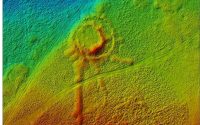
Image: Tony Hunt, from one of his UAV surveys which constructs a 3D image of the ground surface from multiple aerial photographs taken by a drone. The site north to south is large – more than 80m.
Member’s report
An appreciative and clearly knowledgeable audience were treated to a clear and well-structured presentation by Yvonne Luke, Vice-Chair of the Ingleborough Archaeology Group (IAG). Based in Ingleton the group, which was founded in 1996, exists to ‘further research and understanding of the historic heritage of its core area [the Ingleborough massif and its surrounding valleys] by archival research and archaeological investigation.’
Yvonne’s talk was on the remains of a large prehistoric monument complex which survives in Sleights Pasture towards the head of Chapel-le-Dale, or Weysedale as Yvonne prefers to call it. Popularly known as the ‘Druid’s Temple’ the core of the site was scheduled by English Heritage (now Historic England) in 1963 as a Round Barrow owing to the remains of a sub-circular bank and, after an amendment in 1995, it is still listed as such. In the summer of 2021 ‘drone’ surveys were undertaken by Tony Hunt of Yorkshire Archaeological Aerial Mapping followed in the next few months by traditional measured surveys (1:50). These were often undertaken in difficult weather conditions but provided the team with great training for future projects.
The interpretation of the surviving field evidence suggests a site that is much more complicated than previously imagined, a narrative which has been summarised by Yvonne as a ‘comment’ on the Historic England’s listing page and in much more detail on IAG’s website under the following link https://www.ingleborougharchaeologygroup.org.
The earliest part of the site appears to be a low embanked stone circle with an internal diameter of c.28m. There is evidence of one fallen standing stone. The bank is faced with slabs of limestone. Yvonne compared the make-up of the bank with that of ‘The Grange’ stone circle in Limerick. A round cairn, 25m x 23m, was later inserted within the embanked area. Three large linear banks, the longest being 46m, were recorded as being added to around the exterior of the circle and post-dating its original construction.
There is good documentary evidence from an article in the ‘Westmoreland Advertiser and Kendal Chronicle’ that the site was partly excavated in 1828 by John Tatham a local coal mine proprietor and the survey shows about a quarter of the embankment covered in what appears to be excavation debris. The newspaper article also speaks of two spearheads being found, one of bronze and one flint plus among other items a ‘drinking vessel’ which has been suggested from the Beaker period. It was at this time that the site became known as the ‘Druid’s Temple’.
A quarter of the bank had been robbed out and about three-quarters of the cairn with Yvonne claiming that many stones from the complex can be seen in the nearby field walls. She noted that several writers in the late eighteenth and nineteenth centuries described two cairns on the Sleights but no clear evidence of the site of this other cairn has been found and may have been completely removed for use in field boundaries or road construction. Clearly the site has much more to give, and I felt that Yvonne was yearning for some form of excavation particularly of the linear features. A very recent resistivity survey on Sleights Pasture by the group and aerial survey work by Rick Petersen of the University of Central Lancashire may be the next step to that goal.
Jeff Taylor