Stones in Museum Gardens
A work in progress
This is an extended version of the article to appear in the YPS 2020 Annual Report
Peter Hogarth in the book ‘The most fortunate situation’, on the Museum Gardens, writes: ‘The major feature is the unique assemblage of distinguished buildings: the ruins of St Mary’s Abbey, the walls of the Roman fortress of Eboracum and the city walls of medieval York. Together with these are the Grade I listed Yorkshire Museum and Tempest Anderson Hall and several Grade II listed buildings. The Museum Gardens are themselves a Grade II Registered Park and Garden.’
So the Gardens make a prodigious treasury on which to draw.
In early Spring 2020, when times were still normal, The University of Hull arranged for a Geography and Geology undergraduate to undertake a Professional Consultancy Project for the YPS as a module towards his degree.
Rod and Margaret Leonard and I discussed what we felt could best be achieved with The Geology Group and settled for the idea of a database with the location, description and rock type of as many of the different stone sites in the Yorkshire Museum Gardens as was convenient in the time allotted.
Simon Heath was able to come through to York from Hull a couple of times to walk round the gardens with us and then by himself before the University banned any more travel for all students after the pandemic lockdown began.
Simon then produced a remarkable desk-based report/set of data using material he had gathered at speed, expecting to be able to return to check items and fill in gaps in photographic records.
We are grateful for his most useful contribution and wish him well in the rest of his course – especially under the rather remote and confined circumstances of universities this year.
This is one more project in a line of succession and Simon was able to build on a variety of information from the past; some of it fragmentary, some incomplete and some of uncertain origin.
There were notes on the glacial erratic rocks in the Gardens from the Yorkshire Boulder Committee reports from the late C19th. Duncan Hawley spoke about the history of these Committees and the Yorkshire section in particular at our joint conference in York with the History of Geology Group in 2019. The British Association formed a national Boulder Committee in 1873, but the local committee was founded by the Yorkshire Naturalists Union, primarily for amateurs and was a devolved local activity.
When Paul Ensom was Keeper of Geology at the Yorkshire Museum (1989-97) he wrote a nine-page Stone Guide for use by visitors to the Museum and Gardens. His notes on the history of the major buildings, background to geological features, timescale and environments in which they formed is excellent, but we do not have a map for the locations he identifies, many portable items have been moved or lost and others introduced.
There is a leaflet printed in 1988, still available at the Lodge, ‘Roman, Romanesque and Romantic – 2000 Years of Building in the Museum Gardens’ produced in 1988, with a glossary of architecture and notes on 11 buildings in the gardens, but without discussions on the stones.
When Rod Leonard led the team producing the William Smith mosaic map in 2015, one of the main adjuncts was the array of stones by the side as examples of the succession of geology in the (historic) county. Then there are three leaflets giving details of what to look for in the mosaic and the examples. These are in the Geological Map pages of the YPS website.
In 2017, Paul Hildreth the current President of the Yorkshire Geological Society and an external expert advising the YPS Geology Group, devised ‘The Building Stones of York City Centre Tour’ which went through Mint Yard (by York Explore) to the inside of the city walls and then into the Gardens before moving into the City centre. He focussed on geological time and identifying types and their formation from close examination. He ran this tour several times for the YPS and subsequently for YGS. A video of this tour for YGS website is also planned.
In 2018 the first University of Hull undergraduate to undertake the Consultancy module, Oliver Purvis, was asked to develop a geology trail and map for children and families in the garden. This gave some explanatory detail and 10 sites to look at carefully. The aim to produce the trail on a single sheet meant that the task was always going to be constrained. Nevertheless, Margaret Leonard led several tours based on this material. Oliver’s trail is available on the Geological Map pages of the website.
There were several possible extensions to this project proposed at the time, aiming at different user-groups, for example considering the fossils that can be identified using a hand lens, linking to the collections in the Yorkshire Museum and extending into the City. But these would have to wait.
‘The most fortunate situation’ by Peter Hogarth and Ewan Anderson was first published by YPS in 2018 and describes the intentions of John Murray Naesmyth, who laid out the Gardens between 1844 and 1846 as providing a setting for the Yorkshire Museum and the ancient monuments in its vicinity and to incorporate botanical gardens. ‘a romantic creation conceived for people with both antiquarian and scientific interests who were at home with a variety of styles.’
Of course, the book’s focus is on the nature of a botanical garden, the history of the creation and development of the Gardens, their use over time by the YPS, City and public and the extent to which they did or do achieve botanical status.
It mentions the creation of the Limestone Rock garden in 1981. Now, for the geologist the interest would be in
a) How that rock was acquired:
Was the removal of surface limestone pavement with its clints and grykes from some part of the west of Yorkshire allowed in 1981? The Environment Agency would, I feel sure, prohibit removal these days. Or was it moved from elsewhere in the Garden or another garden?
b) How deposition took place at its source:
The environmental conditions which gave rise to such a deep deposit of calcareous organism remains in shallow waters.
c) How the rock lithified and was subsequently buried under further deposits:
The story of tectonic plate movement, collision, subsidence, uplift, faulting and folding that buried it deep then eroded off the tops to leave it exposed as such dramatic features of limestone paving. The geo-chemistry that explains its nature and current bright white appearance.
So, the aim of the current project is to produce a database to have as a resource which can be put on the YPS website and can be updated as objects move and errors and omissions are dealt with.
This resource can then be drawn on by the Geology Group for different purposes, walks, talks, informing the YPS and the public and offering advice about what is in the Gardens and why they are there.
Thanks to Margaret and Rod Leonard and Paul Hildreth for their support.
Types of stones in the Gardens:
The Yorkshire Museum (but not the Tempest Anderson Hall, a later extension), the steps down from the terrace to the garden and the Observatory. Originally all constructed from Hackness Building Stone, from a quarry owned by Sir John Johnstone of Hackness Hall where William Smith had been made land steward. This honey-coloured stone is from the 156 million year old Middle Jurassic Langdale Beds. It is a fine-grained sandstone with shells and burrows caused by animals in a shallow sea burrowing through the silts to find food and seek protection. This was a time of marine transgression in a period of great river deltas. This part of Yorkshire then lay about where Spain does today. There are traces of bedding showing the layers in which sediment was laid down. There are many later repairs with other materials.
The Limestone Rock Garden uses naturally weathered blocks of Lower Carboniferous Limestone. This is typical of the grey-white limestone pavements of Malham Cove and Ingleborough area with its clints (surfaces) and grikes (fissures). 340 million years ago the area was near the equator and beneath a warm, shallow sea – rich in shelly creatures and corals. The deposits, mainly of calcium carbonate, are over 200 metres thick.
The Roman sarcophagi, in the border near the main entrance and by the hospitium, are relocated from the new railway station which was developed in the 1870’s. This hard, gritty, pebbly sandstone from the Upper Carboniferous, about 320 million years ago, was deposited in deep, fast-flowing river and delta systems. The sediment came from the erosion of extensive mountains to the North of Britain under monsoonal conditions. Romans used this stone for major constructional work in York and the nearest sources are on the Eastern flanks of the Pennines, from North of Leeds to Masham. Brimham Rocks displays excellent examples of graded bedding, cross-bedding and erosion within this gritstone.
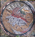
The map commemorates William Smith’s great achievement, the geological map of Britain first published in 1815. It is composed of local and exotic pieces, with fossil ammonites, and is surrounded by a set of examples of the stones that Smith included within the historic county, with a key.
This is one of many pieces of rocks from elsewhere placed around the gardens to show specific characteristics. Some are glacial erratics and some have been preserved from quarrying and mining: Porphyritic Shap granite, ignimbrite – deposits from a burning cloud of explosive ash and gas rolling down the side of a (Lake District?) volcano, cup and ring marked fine sandstones, rock with glacial striations and one with the imprint of a coal-measures tree trunk – a trace fossil or ichnofossil.
The basalt piece is similar to those found at the Giant’s Causeway in Antrim and at Fingal’s Cave on Staffa, NW Scotland. About 60 million years ago, basaltic lava was released from nearby volcanic activity and cracked into columns as it quickly cooled. The Cuillins on Skye are mountains formed from igneous rocks, gabbro, basalt and granite from the same age.
 Dolostone, Dolomite or Magnesian Limestone
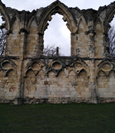
St Mary’s Abbey, The Hospitium, St Leonard’s Hospital St Mary’s Lodge and the Abbey walls are of fine-grained white or sandy-coloured, medieval Magnesian Limestone from the Tadcaster area.
The YPS Lodge, Manor Cottage, the low Museum Gardens walls to the SW and SE and the dais and steps of the Yorkshire Museum entrance are from the Victorian era of similar stone, but probably from quarries further south in Yorkshire along the North/South outcrop of this rock. The Houses of Parliament were rebuilt in 1840 from Magnesian Limestone from Anston Quarry in South Yorkshire, east of Sheffield. Blocks up to four feet thick could be used and easily carved, though the contract was badly supervised and the stone began to decay within ten years.
This Cadeby formation stone from the Permian Period of about 260 million years ago was formed in the shallow Zechstein Sea, in a deep bowl stretching to Germany.
A dry hot climate caused repeated evaporation of the waters, leaving deep salts which are currently mined as fertiliser at Boulby and Whitby. Further east this climate produced the large-scale bedding of desert sandstones in the Appleby area.
The limestones were initially laid down as organic calcium carbonate-rich sediment and magnesium-rich waters circulating afterwards caused a chemical change to dolomite or calcium magnesium carbonate which is much more resistant to acid in rain and soot than other limestones.
The medieval stone has features including current bedding, vugs (holes), stylolites (where limestone is dissolved under great pressure and irregular, zig-zag boundaries result) and bryozoan reef structures.
 Roman Building within the Fortress
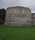
The unpatched lower half of the Multangular Tower and the adjacent Roman Fortress walls are also of Magnesian Limestone of unknown origin – Knaresborough, Wetherby, Tadcaster, Cawood? – but of different characteristics from the later medieval stone. Almost all the older stonework is oolitic or relict oolitic (the centre of the ooliths dissolved out to a void and some recrystallisation) and some is medium grained. Roman stone is here cut to small blocks, so the size and appearance contrasts with the medieval stone.
The Anglian Tower blocks are of Jurassic Limestone from North East Yorkshire (The Cleveland Basin), either Hambleton or Malton Oolite. These grey-white rocks from about 160 million years ago are the deposits of shelly animals and corals and often show the appearance of fish roe (eggs). Working and former quarries of this stone are at Hovingham, Wath and Slingsby. This stone may have been used for lime mortar in the Fortress but was otherwise only used in the civilian areas of Eboracum.
Other stones in the Gardens include:
· York Stone, fine-grained paving made from Elland Flags between Bradford and Halifax. The sea invaded Upper carboniferous coal-forming swamps.
· Middle Jurassic shelly limestones from Lincolnshire.
· Ackworth medium-grained sandstone with small lumps of orange-brown iron oxide called ‘ochre-balls’.
· Scottish, and possibly Cornish, granites.
· Triassic Grinshill sandstone repairs from Shropshire.
· Cobbles of different rock types, deposited by glaciers and transported to the nearby area by rivers of melting ice-wash
· Concrete made of British limestones. For the early reinforced cast concrete of the Tempest Anderson Hall, dolerite aggregates from the Great Whin Sill, slag, and granite were incorporated.
Paul Thornley 6/12/20


